Auction
Price and date
Category
Books (357)
Decorative Prints (31)
Maps (83)
Your browser seems to have JavaScript disabled - please allow JavaScript in order to view lots on this page.
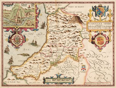
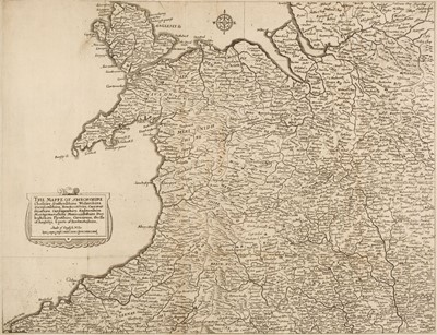
Lot 97 - Cardiganshire. Speed (John), Cardiganshire Described..., 1676
Sold for £140
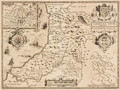
Lot 98 - Cardiganshire. Speed (John), Cardiganshire Described..., 1st edition, 1611
Sold for £220
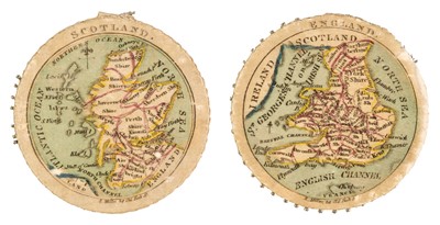
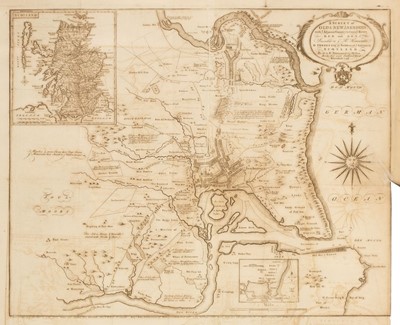
Lot 99 - Cartographic curiosity. Miller (R.). Needle wheels with maps of the Home Nations, circa 1820
Sold for £520
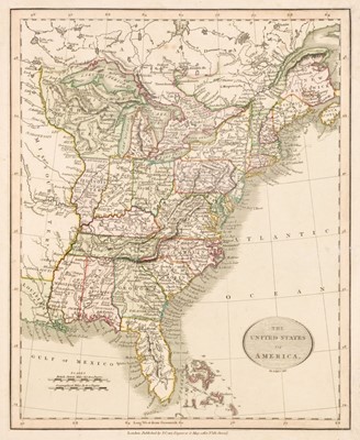
Lot 100 - Cary (John). Cary's New Universal Atlas..., 1829
Sold for £280
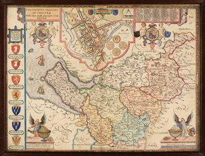
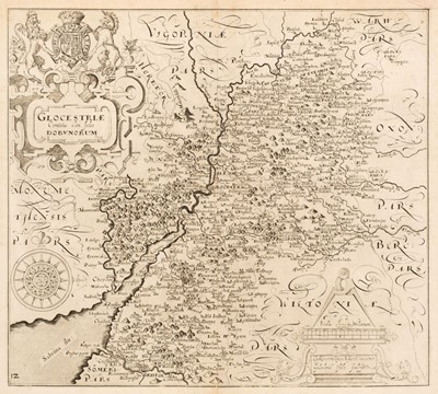
Lot 101 - * Cheshire. Speed (John), The Countye Palatine of Chester..., Thomas Bassett & Richard Chiswell, 1676
Estimated at £200 - £300
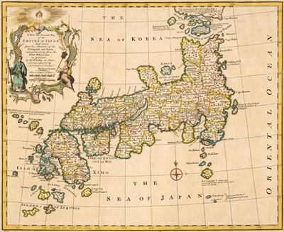
Lot 102 - China & Japan. Bowen (Emanuel), A New and Accurate Map of China..., circa 1747
Sold for £340
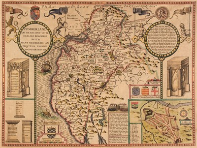
Lot 103 - Cumberland. Speed (John), Cumberland and the Ancient Citie Carlile Described...,1627
Sold for £160
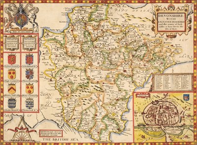
Lot 104 - * Devon. Speed (John), Devonshire with Excester described..., 1st edition, 1611
Sold for £400
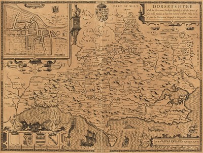
Lot 105 - * Dorset. Speed (John), Dorsetshyre with the Shyre Towne Dorchester described..., 1st edition, 1611
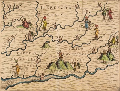
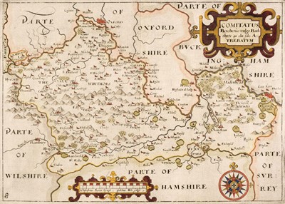
Lot 106 - * Drayton (Michael). Untitled map of Hereford, Worcester and Gloucestershire, 1612 - 22
Sold for £120
Lot 107 - * Durham. Speed (John), The Bishoprick and Citie of Durham, 1st edition, circa 1611
Sold for £130
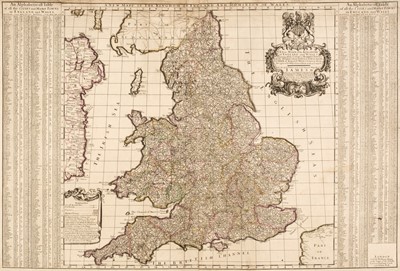
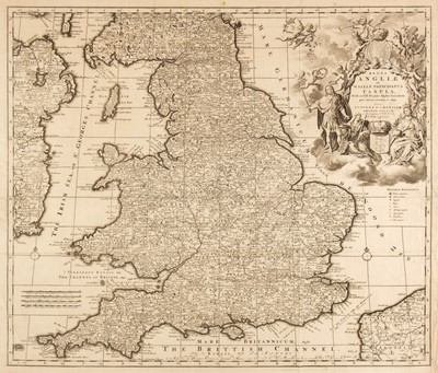
Lot 108 - England & Wales. Berry (William). A New Mapp of the Kingdome of England and Wales..., 1685
Sold for £750
Lot 109 - England & Wales. Covens (J. C. & Mortier C.), Regni Angliae et Walliae principatus..., 1735
Sold for £300
Lot 110 - Europe. A mixed collection of approximately 150 maps, 18th & 19th century
Sold for £380
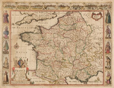
Lot 111 - * France. Speed (John), France Revised and Augmented..., 1676
Sold for £360
Lot 112 - Geological County Maps. Cary (John), Northamptonshire and Huntingdonshire, 1821
Sold for £100
Lot 113 - Hall (Sydney). Black's General Atlas..., 1840
Sold for £260
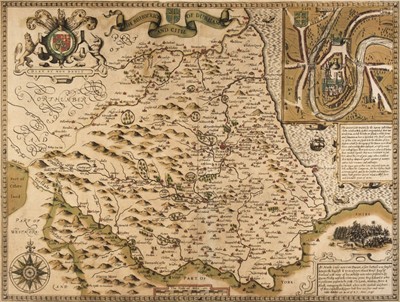
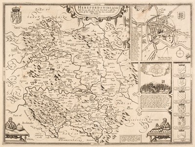
Lot 114 - Herefordshire. Speed (John), Hereford - Shire described..., 1st edition, circa 1611
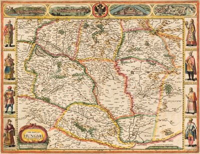
Lot 115 - Hungary. Speed (John), The Mape of Hungari newly augmented..., Roger Rea, 1662
Sold for £650
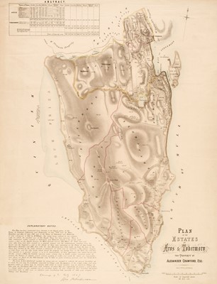
Lot 116 - Isle of Mull. Plan of the Estates of Aros & Tobermory, the property of Alexander Crawford, 1847
Sold for £125
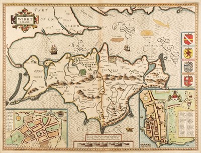
Lot 117 - * Isle of Wight. Speed (John), Wight Island, J. Sudbury & G. Humble, 1627
Sold for £200
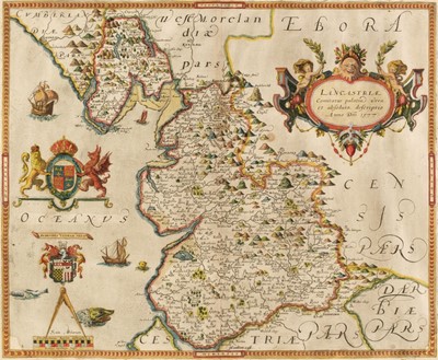
Lot 118 - * Lancashire. Saxton (Christopher), Lancastriae Comitatus palatin vera et absoluta..., 1579
Sold for £2,600
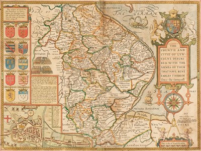
Lot 119 - Lincolnshire. Speed (John), The Countie and Citie of Lyncolne described..., 1676
Sold for £440
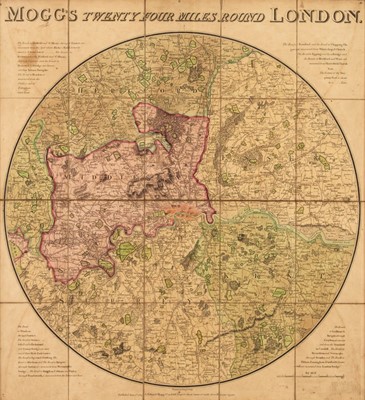
Lot 120 - * London. Mogg (Edward), Mogg's Twenty Four Miles Round London, 1809
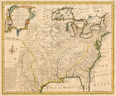
Lot 121 - Louisiana. Bowen (Emanuel), A New and Accurate Map of Louisiana..., circa 1747
Lot 122 - Maps. A collection of approximately 28 British & foreign maps, 17th - 19th century
Sold for £420
Lot 123 - Maps. A collection of ten maps, 16th - 18th century
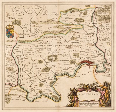
Lot 124 - Middlesex. Blaeu (Johannes), Middle-Sexia, Amsterdam, circa 1650
Sold for £320
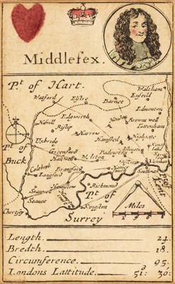
Lot 125 - * Middlesex. Morden (Robert), Playing card map, circa 1676
Sold for £150
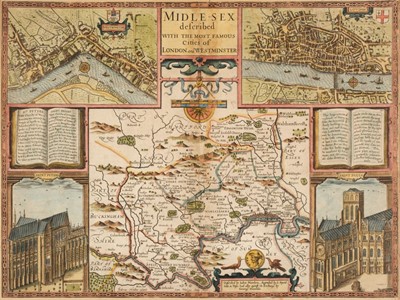
Lot 126 - * Middlesex. Speed (John), Midle-sex described..., George Humble, circa 1627
Lot 127 - Morden (Robert). A collection of 25 maps, 1695 or later
Lot 128 - Morden (Robert). A collection of eleven maps, 1695 or later
Lot 129 - Nichols (J. publisher). Antiquities in Cambridgeshire, Suffolk, Scotland and Wales..., 1790
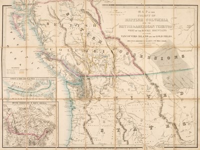
Lot 130 - North America. Wyld (James), Map of the Colony of British Columbia..., and the Gold Fields, 1858
Sold for £5,600
Lot 131 - North Wales. Jenner (Thomas), The Mappe of Shropshire, Cheshire, Staffordshire..., 1671
Sold for £460
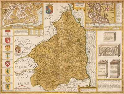
Lot 132 - Northumberland. Speed (John), Northumberland, circa 1676
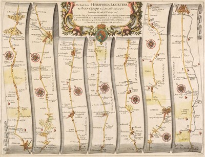
Lot 133 - Ogilby (John). Five strip road maps, 1676 or later
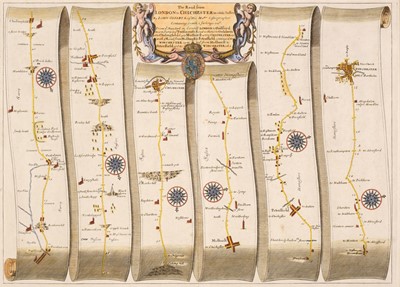
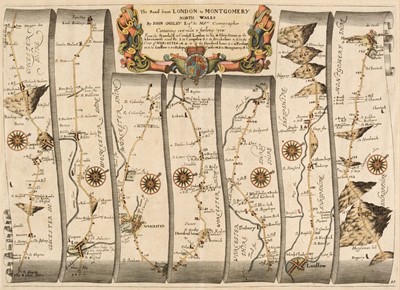
Lot 134 - Ogilby (John). Six strip road maps, 1676 or later
Lot 135 - Ogilby (John). Six strip road maps, 1676 or later
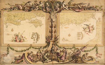
Lot 136 - * Pine (John). Four Sea Charts, numbers 3 & 4, 5 & 6, 7 & 8 and 9 & 10, circa 1739
Sold for £700
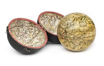
Lot 137 - Pocket Globe. A Correct Globe with the New Discoveries, circa 1785
Sold for £4,800
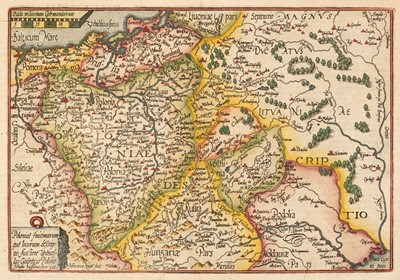
Lot 138 - Poland. Quad (Matthias), Poloniae Finitimarumque Locarum Descriptio..., circa 1600
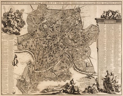
Lot 139 - * Rome. Halma (F., & Van der Aa, Petrus), Novissima et Accuratissima Romae..., circa 1695
Sold for £500
Lot 140 - Saxton (Christopher and Hole G. and Kip G.). Five county maps, 1610 - 37
Lot 141 - Saxton (Christopher and Hole G. and Kip G.). Seven county maps, 1610 - 37
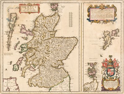
Lot 142 - Scotland. Blaeu (Johannes), Scotia Regnum..., Amsterdam, circa 1654
Sold for £240
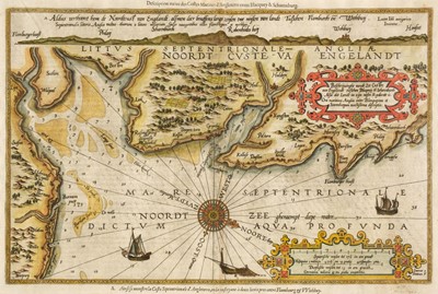
Lot 143 - * Sea Chart. Waghenaer (Lucas Janszoon), Beschrijvinghe vande Zee Custen van Engelandt, circa 1600
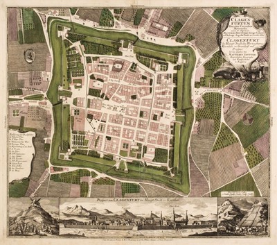
Lot 144 - Seutter (Matthaus). Clagenfurtum Ducatus Carinthiae Metropolis..., Augsburg, circa 1740